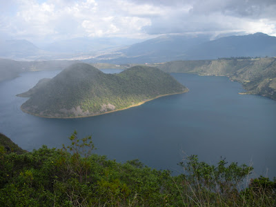
How´d you spend last Saturday? Hiking the perimeter of a volcanic crater lake? ...no?

Well, then I´m guessing it wasn´t as cool as mine!

Tom, Amanda, Meaghan and I left Quito at the verrrry early hour of 7:30, taking the Otavalo bus, then another shorter bus to the town of Cotacachi, and finally riding in the back of a pickup the rest of the way to the volcano.


There´s an unremarkable little tourist area at the base of the volcano, a museum that by all indications was closed, and finally the sendero or trail around the perimeter. Tom´s guidebook told us it would take between five to six hours. Being relatively fit twenty-somethings, we laughed at this estimate. Four hours, tops, for sure...

The next hour or so we spent clambering up steps in what we believed to be the steeper part of the hike, with frequent pauses for pictures of the absolute breathtaking vista, both to our left, into the lake, and to our right, out into the countryside.


Incredibly, not too far into our hike, Tom spotted what I believe to be a condor circling in the currents of air coming over the top of the volcano, without a single flap of his considerable wingspan.


Feeling thus emboldened by our sacred symbol, we pushed on to the highest point in the hike, convinced we had completed at least a good two-thirds within about two hours. Oh... if only we knew...


The top!
The next few hours of the hike went like this:
Jessie falls down while trying to eat candy while descending the steepest part of the hike. Whoops.

Meaghan´s boots actually tie themselves together and trip her. This is only funny because no one got hurt...
"Guys, we´ve GOT to be at least halfway by now."

Half an hour later: "Okay, this is definitely the halfway point."

After the trail veers off into the backcountry for a good 45 minutes: "Well, at least we can see the lake again..."

"Cow pasture?"

"Where are we...?"

Loooong story short, the trail meandered a LOT more than we expected. All told, the hike took us about six hours, including a long detour down a road (definitely not the trail, judging by the number of farm vehicles rumbling by us) through a piece of beautiful, isolated, and apparently very poor farmland.

We probably passed through a total of four or five different types of forests and brush land, from the scrub at the top of the peak, to subtropical behind the volcano, into some strange evergreen anomaly in between cow pastures. Tom had an interesting theory that the fauna varied depending on the patterns of air and therefore moisture carried over from the lake, or blocked by the high volcanic walls. Altitude, of course, would also play a role in the great variety that we saw. By far this is one of my favorite hikes I´ve ever done, and despite the unexpected length and resulting soreness the next morning, I´d go back in a heartbeat.
ahh so much fun! getting "lost" can be an adventure in itself :)
ReplyDelete